Earthquakes
An earthquake of magnitude 7.4 has struck offshore near the Indonesian island of Sumatra, near Aceh province.
The quake struck 214km (133 miles) south of Aceh's capital of Banda Aceh, the US Geological Survey (USGS) said.
A local tsunami alert was issued and later lifted by the Pacific Tsunami Warning Center.
The site is very near that of 2004's 9.2 magnitude earthquake. About 220,000 people were killed in the Indian Ocean tsunami the quake triggered.
The epicentre of the latest quake was at a depth of 61.4km, about 66km (41 miles) south-west of Meulaboh district, the USGS said.
The district, and other parts of Aceh, were devastated in the 26 December 2004 earthquake.
Ring of Fire
The quake hit at 1259 (0559 GMT). Local media reported some houses were damaged and power lines knocked down, Associated Press news agency said.
The Pacific Tsunami Warning Center lifted its tsunami watch several hours after the earthquake.
The earthquake caused some panic in parts of Aceh
"Sea level readings indicate that a significant tsunami was not generated," the Hawaii-based centre said in a statement on its website.
"Therefore, the tsunami watch issued by this center is now cancelled."
The USGS earlier said it believed there was no threat of a destructive, widespread tsunami but the possibility of a local tsunami existed.
Indonesia is located on the volatile Pacific Ring of Fire, a belt of tectonic activity girdling the Pacific Ocean that triggers earthquakes and volcanic activity.
Aceh is on the north-western tip of Sumatra, one of Indonesia's main islands, and is frequently rocked by earthquakes.
One last year near Padang in West Sumatra province killed more than 1,000 people.
About 170,000 people were killed in Aceh from the 2004 earthquake and the tsunami it launched.
The waves spread across the Indian Ocean to cause death and destruction as far away as Sri Lanka, Burma and Thailand.
http://news.bbc.co.uk/2/hi/asia-pacific/8670593.stm
Views: 566
Replies to This Discussion
-
Permalink Reply by Kathy on
-
Magnitude 7.1 - ARAUCANIA, CHILE
2011 January 02 20:20:16 UTC
http://earthquake.usgs.gov/earthquakes/recenteqsww/Quakes/usc0000y49.php
-
-
Magnitude 7.4 - SOUTHWESTERN PAKISTAN
2011 January 18 20:23:17 UTC
Earthquake Details
Magnitude
7.4
Date-Time
Tuesday, January 18, 2011 at 20:23:17 UTC
Wednesday, January 19, 2011 at 01:23:17 AM at epicenter
Location
28.827°N, 63.974°E
Depth
10 km (6.2 miles) set by location program
Region
SOUTHWESTERN PAKISTAN
This event has been reviewed by a seismologist.
-
-
7.2 earthquake hits off coast of Japan
(CNN) -- A tsunami advisory has been issued in Japan after a 7.2 magnitude earthquake struck off the coast of Japan's main island of Honshu, the Japan Meteorological Agency said Wednesday.
The quake was centered 169 kilometers (105 miles) off the east coast of Honshu, directly east of the city of Sendai, the U.S. Geological Survey said.
The quake occurred about 8.8 miles below the earth's surface, the USGS said. The expected height of the tsunami was only expected to be 0.5 meters (19.6 inches).
CNN correspondent Kyung Lah said she could feel the earthquake in Tokyo, 267 miles southwest of the quake's epicenter, and said the shaking lasted as long as three minutes, but that there was no significant damage.
TV Asahi showed video of boats rocking back and forth, as well as images taken from shaken city cams as the earthquake hit.
http://www.cnn.com/2011/WORLD/asiapcf/03/08/japan.quake/index.html?...
-
-
Major tsunami damage in N Japan after 8.9 quake
TOKYO (AP) - Japan was struck by a magnitude 8.9 earthquake off its northeastern coast Friday, unleashing a 13-foot (4-meter) tsunami that washed away cars and tore away buildings along the coast near the epicenter. There were reports of injuries in Tokyo.
In various locations along Japan's coast, TV footage showed massive damage from the tsunami, with dozens of cars, boats and even buildings being carried along by waters. A large ship swept away by the tsunami rammed directly into a breakwater in Kesennuma city in Miyagi prefecture, according to footage on public broadcaster NHK.
Officials were trying to assess damage, injuries and deaths from the quake but had no immediate details.
The quake that struck at 2:46 p.m. was followed by a series of powerful aftershocks, including a 7.4-magnitude one about 30 minutes later. The U.S. Geological Survey upgraded the strength of the first quake to a magnitude 8.9, while Japan's meteorological agency measured it at 7.9.
http://apnews.myway.com/article/20110311/D9LSSI100.html
Magnitude 8.9 - NEAR THE EAST COAST OF HONSHU, JAPAN
http://earthquake.usgs.gov/earthquakes/recenteqsww/Quakes/usc0001xgp.php
-
AdminPermalink Reply by Prodigal Son on -
")
http://www.mirror.co.uk/news/top-stories/2011/03/11/japan-earthquak...Whirlpool off of Japan following earthquake and tsunami. I wonder if this picture looks wrong to anyone else.
-
AdminPermalink Reply by Prodigal Son on -
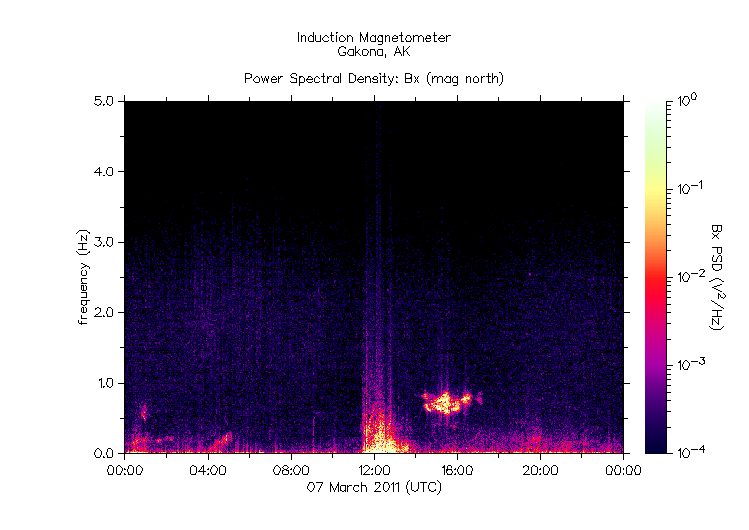
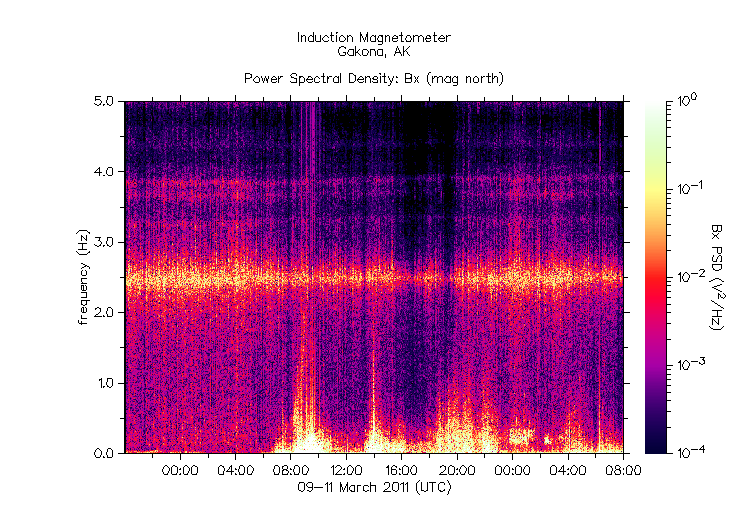
"For the past week prior to the quake, HAARP has been turned off with the induction magnetometer looking something like this everyday:

Sure enough, following a week of electromagnetic silence, HAARP was turned on at approximately 0:00 hours 9 March, 2011 UTC and has been going strong since. Here is the data for the last 36 hours:
http://www.atlanteanconspiracy.com/2011/03/japan-tsunami-caused-by-...
-
AdminPermalink Reply by Prodigal Son on -
Though it might occur that a whirlpool forming as water passes though a narrow outlet would swirl counterclockwise, there is not anything in the picture to indicate that the water is flowing through such an area. It appears to be in a generally open vicinity and flowing as if some force is pulling it downward, in which case it's strange to see it not swirling in a normal clockwise fashion.
-
AdminPermalink Reply by Bean on -
if the counter-clockwise whirlpool (could it have been electromagnetically charged?) draining effect isn't weird enough.. there is a little talk about the Steve Jackson Illuminati gaming card entitled 'Combined Disasters'.. the card features people running from a tumbling clock which highly resembles the Hattori (aka 'Wako') clock tower in Tokyo's affluent Ginza district.. in the card background looks like what could be an explosion along the lines of the power plant fires.
Lg. Wako clock tower photo by Jordy Theiller
Sm. Wako clock tower photo by Arjan Richter
-
-
Two magnitude 7.0 quakes hit Myanmar: USGS
Thu Mar 24, 10:31 am ET
WASHINGTON (Reuters) – Two strong quakes of magnitude 7.0 struck northeast Myanmar, close to the Thai and Laotian borders, the U.S. Geological Survey reported on Thursday.
It said the quakes struck seconds apart at 8:25 p.m. on Thursday (1355 GMT) and were centered 69 miles north of Chiang Rai in neighboring Thailand. The first one was very shallow, at a depth of 6.2 miles, while the second one was deeper at 142.5 miles.
It is a sparsely populated, hilly area best known as the Golden Triangle, which is a traditional source of illicit opium.
(Reporting by Sandra Maler and David Storey; Editing by Bill Trott)
-
FounderPermalink Reply by Cyprium on -
"The only problem with these cards is that there are so many of them that there is a high probability that some will hit their target."
I think it's safe to say that the makers of the NWO cards couldn't predict events, but were working off of a scripted plan that they had knowledge of. The controllers plans don't always go quite as they had it mapped out (thank YHWH), so i believe what we often see depicted in the cards was or will be a goal which might hit its target or miss it to some extent.
No doubt there's disinfo thrown in as well to throw off those that take the cards as sure predictions and give skeptics of the NWO agenda room to dismiss it.
-
-
Magnitude 7.1 - NEAR THE EAST COAST OF HONSHU, JAPAN
http://earthquake.usgs.gov/earthquakes/recenteqsww/Quakes/usc0002ks...
-
AdminPermalink Reply by Prodigal Son on -
"HAARP Website Taken Down to Conceal Evidence of US Weather Modification and Earthquakes?
The HAARP (High Frequency Active Auroral Research Program) website has been down for the past 3 weeks. It was ordered taken down by the US government to conceal US weather modification and earthquake inducing warfare activities against foreign states. The HAARP website was publishing very damaging evidence of US military weather modification and earthquake triggering operations against foreign states. HAARP’s waterfall charts and magnetometer charts gave evidence of an ongoing weather war between the United States government and foreign states. The magnetometer presented concrete evidence that HAARP triggered the Japan earthquake and ensuing tsunami.
HAARP’s magnetometer can be used to predict as well as give evidence of a HAARP created earthquake. A magnetometer measures disturbances in the magnetic field in Earth’s upper atmosphere. HAARP was broadcasting a 2.5 Hz frequency (the signature frequency of an earthquake) from just before midnight on March 8, 2011 and continued to broadcast the frequency for the entire days of March 9, 2011 and March 10, 2011. The 2.5 Hz frequency continued to be broadcasted and recorded by the magnetometer for another 10 hours the day of the Japan 9.0 magnitude earthquake.
Scientists at the HAARP institute discovered that a 2.5 Hz radio frequency is the signature frequency of an earthquake. Since this discovery the HAARP phased array antennas have been used by the US military to beam the earthquake frequency into the ionosphere and the ionosphere reflects it back to Earth – penetrating as deeply as several kilometers into the ground, depending on the geological makeup and subsurface water conditions in a targeted area.. By beaming the frequency at a specific trajectory HAARP can trigger an earthquake any place on Earth. A short burst isn’t enough to disturb solid matter (the Earth crust) so they keep beaming the 2.5 Hz earthquake frequency for hours or days – until the desired effect is achieved.
The Environmental Modification Convention (ENMOD) prohibits the military or other hostile use of environmental modification techniques. It opened for signature on 18 May 1977 in Geneva and entered into force on 5 October 1978. The Convention bans weather warfare, which is the use of weather modification techniques for the purposes of inducing damage or destruction.
Evidence from HAARP’s own website revealed that the US government was acting in violation of the ENMOD treaty – use of weather modification techniques (HAARP) for the purposes of inducing damage or destruction. HAARP broadcasting data published on the HAARP website coincided with a number of recent major catastrophes such as the 2010 Haiti earthquake, the 2010 heatwave in Russia, the major floorings in 2010 in China and Pakistan and the major earthquakes in Haiti and Japan – all occurred since US president and commander-in-chief of the United States military Barack Hussein Obama took office..."
full article:
http://beforeitsnews.com/story/573/777/HAARP_Website_Taken_Down_to_...
Article with magnetometer graph showing the precise time of the Japan quake:
http://presscore.ca/2011/?p=1624
© 2025 Created by Cyprium.
Powered by
![]()